Announcement

Collapse
No announcement yet.

possible problem on horden banks

Collapse
X
 
  • Filter
  • Time
  • Show
Clear All
new posts

  • possible problem on horden banks

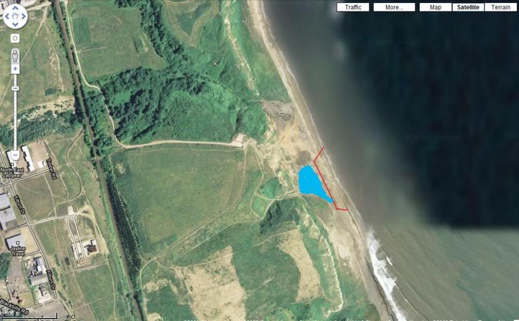
    any you guys using a vehicle on the banks to go fishing, had the dogs on the cliffs above the area below the tip access, it looks like a large area of the banks has fell away and the flooded area was near to the banks edge
    i have filled in the problem area, blue for water and red were it looks as if the banks dropped away, hate one you guys to go down there at night and have an accident, hard to judge how far the water is from the bank edge but it looks very close and a risky chance to take a vehicle near the area[IMG][/IMG]
  • #2
    Horden

    Hello Mike,Is this anywhere near the access point going down the concrete road.
    I'm unable to spot this mark you describing sorry.
    Have you been down lately,is there much water in the stream with the amount of rain lately must be bad going for 4x4s.

    Comment


    • #3
      the mark pictured is to the right of the flight,black water area.there was a couple of 4x4 down on saturday so i'm asuming its ok where u are on about.

      Comment


      • #4
        hi harry pic is of north end of beach not deneholm end .it does fish better north end before xmas ground a bit more mixed ground though.

        better off going back up alcan for them lunker cod.
        Last edited by john/r; 23-11-2009, 06:32 PM. Reason: missed word out
        did you know panel pins comes in diff sizes ?

        Comment


        • #5
          Horden

          Yes,I can see it now thanks lads.
          John gave Lynemouth a shot on Sunday,fished just to the south of the stream
          Gipsy site end never had a bite mate and fished from midday till just dark,nice south east sea running with a quite strong south wind.
          Crabs well fed mine.
          Could see a lot of inshore net markers on the 1/2mile mark.
          Back there next weekend or Horden just out of bounds of the Seaham boundaries

          Comment


          • #6
            hi harry, soz late reply, it was off the top of the cliffs i spotted it, im often up there with the dogs - hence me seeing the difference i mentioned
            yeah if the rivers up it can be a bit hairy getting over, i have not been down as i have damaged my hand, what i normally find is the river goes mad a couple of days after the rain, then drains away over about the same time, i did have a marker on the opposite bank that would give me an idea of depth, either it got washed away or the kids lifted it out

            more the issue now is the old roadway past that, they have made a ramp which means we have to use a track closer to the marsh area and that last time i was over it was quite wrecked from 4*4`s using it and bogging down/spinning out, it could do with a few tons of hardcore dropping on the area lol

            Comment


            • #7
              Horden

              Areet mate,thought it might be awash the river,but whats this ramp??????who's they??????can you still not drive the old coalpickers route anymore,its the only safe ground to travel on to gain access with 4x4s.
              Seen to many bogged down in the swamps off the roadway.
              Fishing any good this year,gonna have a reccy maybe Thurs so don't go to far away from yr phone.......might need a towout

              Comment


              • #8
                Was along there yesterday and you are right it has collapsed in a few places leaving some drops at apprx 6ft. The narrowest part between the bank and the water must be about 8-10 foot, not a great lot considering the weight of the vehicles. I had to delve into the water slightly just to make sure that i could pass without the bank giving but i dare say the bank(ledge) will not last long as there are cracks all along where it is about to give again. Shame really but i think the north end will be out of bounds by 4x4 in the next couple of weeks.

                Comment


                • #9
                  Horden

                  Originally posted by Durham-Lad View Post
                  Was along there yesterday and you are right it has collapsed in a few places leaving some drops at apprx 6ft. The narrowest part between the bank and the water must be about 8-10 foot, not a great lot considering the weight of the vehicles. I had to delve into the water slightly just to make sure that i could pass without the bank giving but i dare say the bank(ledge) will not last long as there are cracks all along where it is about to give again. Shame really but i think the north end will be out of bounds by 4x4 in the next couple of weeks.
                  Thanks for the infomation mate will take care when I go down next.
                  Mike....Thanks for the pm Ive left you my mobile number hope I dont need to ring you............but.

                  Comment


                  • #10
                    Horden

                    Originally posted by Durham-Lad View Post
                    Was along there yesterday and you are right it has collapsed in a few places leaving some drops at apprx 6ft. The narrowest part between the bank and the water must be about 8-10 foot, not a great lot considering the weight of the vehicles. I had to delve into the water slightly just to make sure that i could pass without the bank giving but i dare say the bank(ledge) will not last long as there are cracks all along where it is about to give again. Shame really but i think the north end will be out of bounds by 4x4 in the next couple of weeks.
                    Sent you a pm

                    Comment

                    Working...
                    X